
Day 8 - Socorro NM to Holbrook AZ
| Miles for the Day: | 305 |
| Total Trip Miles: | 2607 |
| Start Point: | Socorro, NM |
| Start Weather: | At 6:00 AM MDT, the temperature was 47.9 degrees with 29 percent humidity. The conditions were clear. |
| End Point: | Holbrook, AZ |
| End Weather: | At 6:00 PM MST, the temperature was 64.9 degrees with 18 percent humidity. The conditions were clear with a wind speed of 11.5. |
| Sun Rise: | 6:51 AM MDT |
| Sun Set: | 6:43 PM MST |
Table of Contents
 Google Map Track Log
 YouTube Video
 Petrified Forest National Park AZ
View a list of places like this or a map.wikipedia.org
Petrified Forest National Park is an American national park in Navajo and Apache counties in northeastern Arizona. Named for its large deposits of petrified wood, the park covers about 346 square miles, encompassing semi-desert shrub steppe as well as highly eroded and colorful badlands.
The Petrified Forest is known for its fossils, especially fallen trees that lived in the Late Triassic Epoch, about 225 million years ago. The sediments containing the fossil logs are part of the widespread and colorful Chinle Formation, from which the Painted Desert gets its name. Beginning about 60 million years ago, the Colorado Plateau, of which the park is part, was pushed upward by tectonic forces and exposed to increased erosion. All of the park's rock layers above the Chinle, except geologically recent ones found in parts of the park, have been removed by wind and water. In addition to petrified logs, fossils found in the park have included Late Triassic ferns, cycads, ginkgoes, and many other plants as well as fauna including giant reptiles called phytosaurs, large amphibians, and early dinosaurs. Paleontologists have been unearthing and studying the park's fossils since the early 20th century.

Bobby

Bobby

Bobby


Bobby


Bobby

Bobby

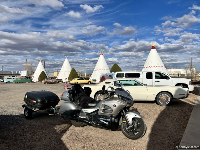
 Wigwam Motel, Holbrook AZ
View a list of places like this or a map.nps.gov
In the arid Arizona desert, the Wigwam Village Motel in Holbrook still provides Route 66 aficionados the opportunity to "Sleep in a Wigwam!"
While passing through Cave City, Kentucky in 1938, Chester E. Lewis was impressed by the distinctive design of the original Wigwam Village constructed in 1937 by architect Frank Redford. An astute observer may notice that the Wigwam Village is not composed of wigwams but of teepees. Mr. Redford, who patented the wigwam village design in 1936, disliked the word 'teepee' and used 'wigwam' instead.
Mr. Lewis purchased copies of the plans and the right to use the Wigwam Village name. The purchase included a royalty agreement in which Mr. Lewis would install coin operated radios, and every dime inserted for 30 minutes of play would be sent to Mr. Redford as payment. Seven Wigwam Villages were constructed between 1936 and the 1950s. Finished in 1950, Mr. Lewis' village was the sixth, thus its designation as Wigwam Village #6.


 Elevation Changes During the Day
The day started at 4,583 feet and ended at 5,050 feet. The highest altitude was 7,933 feet and the lowest altitude was 4,578 feet.
| Day 7 - Socorro NM and Trinity Site |
Topics
TagsConfederate Statues (32),Motorcycle (100),National Parks (9),Odd (1),Route 66 (33),Unemployment (6),Zombies (1)